MUNGER
Situated in 250-23’ N. and 860-26’ E.
It is the headquarter of MUNGER Commissionary. The town is practically surrounded by the Ganga on three sides, viz. south west and north and the Kharagpur hills forming the eastern border. It is situated in the heart of the district and its particular location has made portion of the town a beauty spot. The situation was once considered to be strategic. Munger has a beautiful townscape. Prior to the CENSUS OF INDIA- 1971, Monghyr was in vogue as its name.
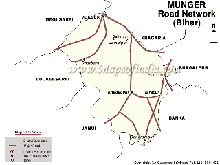
Munger District is located in the southern part of Bihar and its headquarter is located on the southern bank of river Ganges. The district is spread over 1419.7 Sq. km. accounting for 3.3% of the area of Bihar . It lies between 240 22 N to 250 30 N latitude and 850 30 E to 870 3 E longitude. From administrative and development point of view,Munger is divided into three subdivisions namely Munger,Kharagpur, and Tarapur. There are nine developmental blocks namely Munger, Bariarpur, Jamalpur, Dharahara, Kharagpur, Tetia Bambar,Tarapur Asarganj and Sangrampur. There are about 903 villages in the district. The Munger district on an average is 30 to 65 mtrs above sea level. The average annual rainfall is 1231 mm.
For More Please Visit : http://munger.nic.in/
posted by Manoranjan Kumar at 3:59 AM
![]()

0 Comments:
Post a Comment
<< Home